

The giant wave of Icy Bay
April 18, 2016
Ned Rozell
474-7468
A landslide last fall caused a giant wave of the type not seen in Alaska since the storied 1958 event in Lituya Bay.
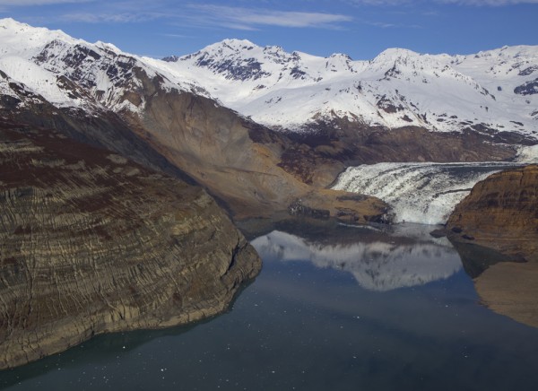
After a period of heavy rains, a mountainside near Tyndall Glacier collapsed into a fiord of Icy Bay on Oct. 17, 2015. The displaced water generated a wave that sheared alders more than 500 feet up on a hillside across from the slide.
To put that in perspective, the 2011 tsunami in Japan reached about 130 feet above sea level. The Icy Bay wave may be the largest since a magnitude 8 earthquake shook much of a mountain into Lituya Bay in 1958. The wave that followed ripped spruce from 1,700 feet up a mountain slope and left trimlines in the bay that are visible today.
Last October, seismologists at Columbia University in New York detected the Icy Bay landslide on their instruments. Göran Ekström and Colin Stark specialize in picking up landslide signals. They figured the slide spilled 200 million tons of rock in 60 seconds.
Winter snows hid the extent of the wave generated from the rock avalanche. Upon hearing a report from a pilot colleague that the landslide area of Icy Bay was free of snow, glaciologist Chris Larsen flew there in his Cessna 180 from his home in Fairbanks. The Geophysical Institute professor used a camera system mounted in his plane to make a high resolution map of the landslide and the path of the megatsunami.
"It almost blows away everything in the historical record except for Lituya Bay," he said. "It's really a unique event to have a tsunami 100 meters high."
The landslide dumped rocks and soil into a finger of Icy Bay known as Taan Fiord. The avalanche debris also covered the tongue of Tyndall Glacier where it dips into salt water. Seconds after the mass hit the water, a wave swept down the fiord.
Unlike during the Lituya Bay tsunami — during which three anchored boats were sunk by or rode atop a 100-foot wall of water — no fishermen were in Taan Bay at the time of the slide.
"If it was September or any time in the summer, the wave could have gotten a fishing boat or two," Larsen said.
The Icy Bay landslide was larger than the amount of rock and soil a huge earthquake shook into Lituya Bay on a July day in 1958. But the Lituya Bay wave was larger because it fell from a higher elevation into deeper water.
Scientists estimate the Icy Bay slide might be the biggest nonvolcanic landslide, by volume, in North America’s written history. Icy Bay and places like it will have more landslides as time goes on, Larsen said. Warmer temperatures melt more glacial ice that buttress hillsides. When the ice melts, oversteepened slopes will fail. Sometimes it takes a big rain or an earthquake to shake them down.
"These megatsunamis are infrequent in the historical record but will most likely increase," Larsen said.
Since the late 1970s, the University of Alaska Fairbanks' Geophysical Institute has provided this column free in cooperation with the UAF research community. Ned Rozell is a science writer for the Geophysical Institute.