

UAF researcher explores blue holes for climate change clues
June 23, 2016
Meghan Murphy
907-474-7541
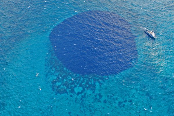
Coastal scientist Christopher Maio rested his eyes on a column of indigo known as a blue hole. The surrounding blue-green waters leveled over reefy shallows.
From the back of a boat, Maio and a group of researchers lowered a metal tube to the blue hole’s floor 150 feet below to capture one of many sediment cores.
At the blue hole’s bottom were alternating layers of thick, dark organic matter and thin white layers of coarse sands. Dark signifies an ocean at rest. White attests to turbulence. In sum, they create a zebra-striped history of local hurricanes that possibly dates back 10,000 years.
“Looking at a long storm history is the best way to understand the relationship between hurricanes and climate in order to assess future risk,” Maio said.
That long storm history is lacking. Historical records only go back a couple hundred years, if that, through ship logs and newspaper accounts.
Scientists like Maio are trying to fill in the timeline. He is an assistant professor of geosciences with the University of Alaska Fairbanks College of Natural Science and Mathematics. He hopes to reconstruct several thousand years of large storm history in the Bering Sea.
So why was he in the Bahamas?
The pitch
Maio received an enticing pitch from his mentor, coastal scientist Jeff Donnelly of the Woods Hole Oceanographic Institution in Massachusetts, that went something like this:
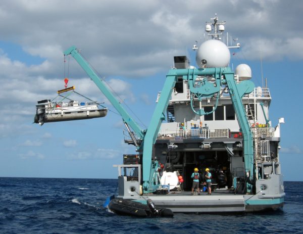
Would Maio be interested in visiting 10 blue holes in the Bahamas, the Turks and Caicos and Haiti aboard businessman Ray Dalio’s private research vessel, the Alucia? Dalio is donating the ship’s time and crew to the research.
Sure
Would he mind if a film crew recorded the April research trip for the second season of the documentary television series “Years of Living Dangerously,” which will air on the National Geographic Channel this fall?
Not at all
Would he feel comfortable with two vampires on board?
Um … what?
Each episode of the show features a celebrity host who investigates a certain aspect of climate change. Actor Ian Somerhalder, who stars in the television show “The Vampire Diaries” and acted in the first season of the TV show “Lost,” was the celebrity host investigating how climate change will affect hurricane activity. He brought his wife Nikki Reed, who acted in the vampire movie series “The Twilight Saga.”
Together — the ship’s operating crew, the film crews, the actors/vampires and the scientists — traveled to the blue holes to learn about the research that will eventually be broadcast to the world.
What will the world learn? (You heard it here first)
“Right now many people say recent warming will increase storm occurrence and intensity, but it’s more complicated than that,” Maio said.
The dynamics that regulate storm occurrence, frequency and location are complex, and the factors that increase storms in one area may lessen them in another, Maio said.
Examining records of large storms during the last 10,000 years, when the climate cooled and warmed, could improve scientists’ understanding of how a changing climate affects large-storm activity now and in the future, Maio said.
To start developing that record, Maio said Donnelly turned to underwater features near coastlines that have trapped sediments over thousands of years.
They can be basins, salt marshes or blue holes, as long as their waters were deep enough 10,000 years ago for layers to grow until today.
Being near the coastline and vegetation is key. It means dark organic sediments form layers when the waters are quiet. Then contrasting layers of heavier, larger sediments form when a powerful enough storm system roils the waters and shovels the sediments in.
Core samples are taken from the feature’s bottom, where the layers provide a chronology. Scientists use methods like radio-carbon dating to determine the age of the organic layers.
Although Donnelly pioneered this technique, many students and researchers like Maio who have worked with him are carrying on this work in different parts of the world. They hope their combined research will paint a historical picture of storm activity on a global scale.
Quite a few of those students and researchers have formed what Maio calls the “A-Team of coring” in the Bahamas. He hopes the same team will help him when the time comes to collect sediment cores off Alaska's shores.
“I want to carry on this work in the Bering Sea because Alaska’s coastlines are certainly at risk from large storms,” he said. “To understand Bering Sea storms, we really need 10 to 15 good coring sites.”
Maio is still searching for sites, as are his colleagues in their respective parts of the world. On a boat ride back from a blue hole one night under the twinkling stars, they hatched a plan.
“We were thinking we should have our own reality TV show,” he said, one that follows the researchers all over the world as they explore coastal sediments. “We’ll call it the ‘Mud Hunters.’”