

Satellite imagery allows a look back in time at the world's oceans
June 25, 2013
A time capsule of satellite imagery of the earth will become available to scientists this month.
On June 28, digital imagery from more than three decades ago will be released by the Alaska Satellite Facility at the University of Alaska Fairbanks Geophysical Institute, NASA’s processor and distributor for this type of data. The images reveal an unprecedented view of sea ice, waves, forests, glaciers and more.
“It was awesome because I was resurrecting data that nobody has seen in 35 years, pictures of the earth from when I was a child,” said Tom Logan, the software engineer who processed the data.
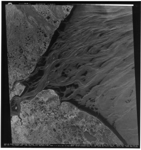
The NASA Seasat satellite was launched in June 1978 as proof of concept for using satellites to monitor ocean features—like temperatures, wind and waves. Four months later, a major power failure killed the mission. For 35 years much of the imagery was stowed away in filing cabinets.
Now the data has been processed into several thousand unique gray-scale images of the earth’s surface, each displaying 100-square-kilometer sections in high resolution.
Data was collected over all of North America and much of northern Europe, so there is imagery of the Arctic Ocean, Bering Sea, and other surrounding waters. You can detect whether lakes are frozen or thawed, the pattern of waves, and even boats.
“It’s a little boat with a big V visible from the ship’s wake,” Logan said.
This mission was NASA’s debut of synthetic aperture radar (or SAR) in space. SAR bounces a little pulse of energy off the surface of the earth and listens for the echo with an antenna. It’s “synthetic” because it collects the echoes from many radar pulses and processes them into a single radar image.
“It’s like combining 1,500 looks at the ground into one look,” Logan said.
This information can be used by a wide range of scientists. A biologist studying the impact of climate change on the boreal forest can now rewind to see the land cover back in 1978. A geophysicist studying receding sea ice has even older baseline data to compare rates of melting and other qualities.
“You can determine the age of the sea ice, whether it’s multi-year or new ice. And you can watch the ice move so you can see fracture patterns and see how the ice floes work,” Logan said.
Radar can see through darkness and clouds, unlike other monitoring tools. This can be handy for researchers looking at glaciers or volcanoes in the middle of nowhere, far from GPS stations or cameras.
“That’s really the niche that SAR data fills, the ability to provide data about some geographic feature that scientists can’t get in any other fashion,” said Gwen Bryson, a data quality engineer on the project.
If the satellite had circled the earth more times, you could even clock the movement of glaciers and watch the inflation and deflation of volcanoes.
The release was partly spurred by growing demand for the data by the science community. Plus there are no other SAR “birds” in space right now.
“There’s nothing new coming in, so let’s go back and mine what has previously been taken,” Bryson said.
It’s also more accessible than ever. Using 1980s technology, it would have taken a week to process five scenes, Logan said.
“Now we process a scene every 5 minutes.”
Yet it didn’t happen at the click of a mouse. First he had to clean some “bit rot” off of data that had been sitting on aging tapes for decades. Then he filtered the data six times to make sure the metadata (time, coordinates) for the imagery was correct. After developing software to decode telemetry and sort the data, he configured the files so they could be synthesized into single images.
“I don’t think anybody has dealt with SAR data this old,” Logan said. “It took a lot of creative problem solving to figure out the best way to get the raw data to be correct.”
The images will be available at the Alaska Satellite website at http://www.asf.alaska.edu/
Since the late 1970s, the University of Alaska Fairbanks’ Geophysical Institute has provided this column free in cooperation with the UAF research community.