

Satellites, drones can help predict path of wildfire smoke
April 26, 2016
Sue Mitchell
907-474-5823, mobile 907-978-2040
University of Alaska Fairbanks atmospheric scientists are developing ways to help forecast air quality in areas downwind from wildfires.
Nicole Mölders and her colleagues used computer models derived from well-studied past wildfires to assess the likely effectiveness of two different data-collection tools during a real fire: satellite-borne instruments that can scan smoke clouds to tell scientists which chemical compounds and particulates are present in the plume, and drones to safely gather information from the smoke cloud in remote locations.
The work by the researchers, all with the UAF Geophysical Institute and funded by NASA, was published in two papers in the Open Journal of Air Pollution.
“These data collection methods could be used to develop short-term air quality forecasts during a fire — between six and 24 hours in advance of the smoke’s arrival,” Mölders said.
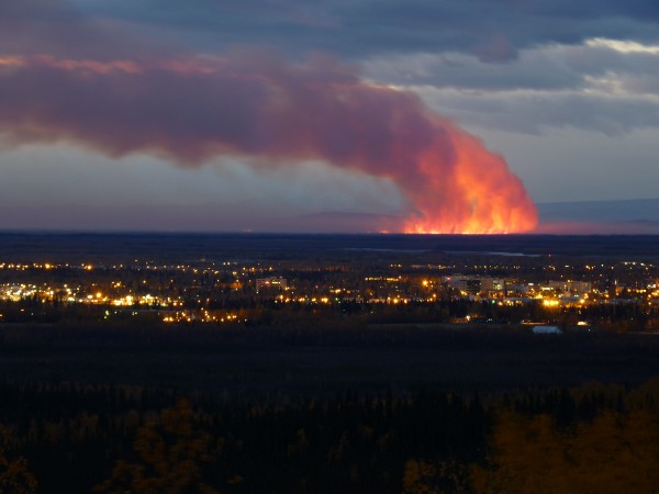
Alaska, particularly the Interior, is prone to wildfires due to usually dry, warm summers, an increasing trend in recent years. Smoke density in downwind communities and the negative health effects on residents can be considerable. Wildfire smoke also affects aircraft safety and ground traffic due to decreased visibility.
“Improved predictions of smoke production and movements is one of fire managment's research priorities,” said Randy Jandt, a fire ecologist with the Alaska Fire Science Consortium at UAF. Jandt noted there have already been 68 fires in Alaska so far this year, for a total of 92 acres burned — all human-caused.
A major difficulty with making air quality forecasts during wildfires in Alaska’s Interior is the lack of ground-based measuring sites. The remoteness of many wildfires and the sparse population results in a limited number of ground-based air quality data-gathering or meteorological sites. Satellites and drones — also called unmanned aerial vehicles —could help gather more data to predict downwind air quality.
Cathy Cahill, UAF professor and director of the Alaska Center for Unmanned Aircraft Systems Integration, said it’s dangerous to collect this kind of data using airplanes because the smoke results in visual as well as health challenges for the pilot.
“These studies using models of the smoke plume movement from real fires gave us the opportunity to determine if satellite data and UAVs would give you useful information. This work makes it possible to definitely say ‘yes',” Cahill said.
Mölders and her colleagues used computer models created from data collected during the 2009 Minto Flats South wildfire to assess performance of the CALIPSO (Cloud Aerosol Lidar and Infrared Pathfinder Satellite Observations) satellite in collecting data about particulates in the smoke and the 2009 Crazy Mountain Complex wildfire to determine the viability and best flight paths to collect information with UAVs.
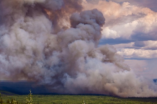
CALIPSO’s light detection and ranging sensors, called lidar, can collect data 14 times a day about the vertical distribution of many different kinds of particles and chemicals in a smoke cloud, like a curtain view of what’s directly beneath the satellite, Mölders said. But lidar can’t penetrate clouds, which is where UAVs could be particularly useful.
Using the computer model, the researchers figured out the UAV sampling frequency and data collection patterns that would be most efficient and effective, without having to fly the UAVs in test patterns through smoke from a real fire. It would be too risky with fire mitigation efforts going on at the same time, Mölders said.
“This is the power of computer models. You can use models to do things you couldn’t afford to do or that would be unsafe,” Mölders said. “Models make it possible to figure out the best course of action when resources are limited.”
Cahill is optimistic about future usefulness of these technologies.
“It’s too early to project when these kinds of satellite data or model-generated UAV flight plans might be used on an actual fire,” Cahill said, “but the foundation is now laid to show it’s possible.”
ADDITIONAL CONTACTS: Nicole Mölders, 907-474-7910, cmoelders@alaska.edu; Catherine Cahill, 907-474-6905, cfcahill@alaska.edu
ON THE WEB: Geophysical Institute, gi.alaska.edu
ACUASI, http://www.gi.alaska.edu/facilities/acuasi/
Atmospheric Sciences, http://www.gi.alaska.edu/research/atmospheric-sciences
Open Journal of Air Pollution, http://www.scirp.org/journal/ojap/
Theoretical Investigations on Mapping Mean Distributions of Particulate Matter, Inert, Reactive, and Secondary Pollutants from Wildfires by Unmanned Air Vehicles, dx.doi.org/10.4236/ojap.2015.43014 (PDF)
Assessment of WRF/Chem Simulated Vertical Distributions of Particulate Matter from the 2009 Minto Flats South Wildfire in Interior Alaska by CALIPSO Total Backscatter and Depolarization Measurements, dx.doi.org/10.4236/ojap.2015.43012 (PDF)